


Tour des Aiguilles rouges - Tronçon 5 La Flègère au Col du Brévent

Kargil
User GUIDE
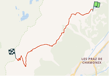

Length
6.4 km

Max alt
2361 m

Uphill gradient
635 m
Km-Effort
13.3 km

Min alt
1810 m

Downhill gradient
157 m
Boucle
No
Creation date :
2020-06-05 11:23:43.419
Updated on :
2020-06-05 16:29:17.642
2h50
Difficulty : Difficult

FREE GPS app for hiking
 SityTrail
IGN / Geographical institutes
SityTrail Plus
The world is yours!
About
Trail Walking of 6.4 km to be discovered at Auvergne-Rhône-Alpes, Upper Savoy, Chamonix-Mont-Blanc. This trail is proposed by Kargil.
Description
Du Refuge de La Flégère au Col du Brévent
Positioning
Country:
France
Region :
Auvergne-Rhône-Alpes
Department/Province :
Upper Savoy
Municipality :
Chamonix-Mont-Blanc
Location:
Unknown
Start:(Dec)
Start:(UTM)
336280 ; 5091771 (32T) N.
Comments