


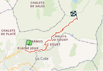
Tour des Aiguilles rouges - Tronçon 1 Plaine Joux à Moëde Anterne

Kargil
User GUIDE

Length
8.7 km

Max alt
2033 m

Uphill gradient
788 m
Km-Effort
17.1 km

Min alt
1278 m

Downhill gradient
134 m
Boucle
No
Creation date :
2020-06-05 11:23:42.76
Updated on :
2020-06-07 09:40:58.029
3h21
Difficulty : Difficult

FREE GPS app for hiking
 SityTrail
IGN / Geographical institutes
SityTrail Plus
The world is yours!
About
Trail Walking of 8.7 km to be discovered at Auvergne-Rhône-Alpes, Upper Savoy, Passy. This trail is proposed by Kargil.
Description
Parking de Plaine Joux au Refuge de Moëde Anterne
Tronçon N°1 d'un parcours en 9 tronçons assemblables selon selon objectif de chaque journée et proposant 2 variantes à partir du col du Brévent.
Positioning
Country:
France
Region :
Auvergne-Rhône-Alpes
Department/Province :
Upper Savoy
Municipality :
Passy
Location:
Unknown
Start:(Dec)
Start:(UTM)
324660 ; 5091051 (32T) N.
Comments