


le Pas de l'Aze

ARVIEU
User
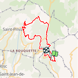

Length
19.4 km

Max alt
707 m

Uphill gradient
763 m
Km-Effort
29 km

Min alt
306 m

Downhill gradient
732 m
Boucle
No
Creation date :
2014-12-10 00:00:00.0
Updated on :
2014-12-10 00:00:00.0
6h18
Difficulty : Difficult

FREE GPS app for hiking
 SityTrail
IGN / Geographical institutes
SityTrail Plus
The world is yours!
About
Trail Walking of 19.4 km to be discovered at Occitania, Hérault, Arboras. This trail is proposed by ARVIEU.
Description
le Pas de l'Aze
Positioning
Country:
France
Region :
Occitania
Department/Province :
Hérault
Municipality :
Arboras
Location:
Unknown
Start:(Dec)
Start:(UTM)
537688 ; 4841777 (31T) N.
Comments