


Tour des Aiguilles Rouges - Tronçon 6.1 Col du Brévent à Moëde Anterne

Kargil
User GUIDE
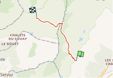

Length
8.1 km

Max alt
2364 m

Uphill gradient
417 m
Km-Effort
14.9 km

Min alt
1594 m

Downhill gradient
789 m
Boucle
No
Creation date :
2020-06-05 16:34:39.117
Updated on :
2020-06-05 16:39:24.739
2h47
Difficulty : Difficult

FREE GPS app for hiking
 SityTrail
IGN / Geographical institutes
SityTrail Plus
The world is yours!
About
Trail Walking of 8.1 km to be discovered at Auvergne-Rhône-Alpes, Upper Savoy, Chamonix-Mont-Blanc. This trail is proposed by Kargil.
Description
Pour Retour vers Plaine Joux depuis le col du Brévent à la suite du tronçon 5
Positioning
Country:
France
Region :
Auvergne-Rhône-Alpes
Department/Province :
Upper Savoy
Municipality :
Chamonix-Mont-Blanc
Location:
Unknown
Start:(Dec)
Start:(UTM)
332848 ; 5089793 (32T) N.
Comments