


pont de l'aille juin 2020

soca
User
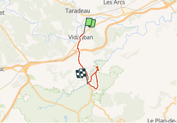

Length
15.5 km

Max alt
89 m

Uphill gradient
137 m
Km-Effort
17.3 km

Min alt
42 m

Downhill gradient
148 m
Boucle
No
Creation date :
2020-06-05 07:31:40.319
Updated on :
2020-06-05 19:30:12.202
3h45
Difficulty : Very easy

FREE GPS app for hiking
 SityTrail
IGN / Geographical institutes
SityTrail Plus
The world is yours!
About
Trail Walking of 15.5 km to be discovered at Provence-Alpes-Côte d'Azur, Var, Vidauban. This trail is proposed by soca.
Positioning
Country:
France
Region :
Provence-Alpes-Côte d'Azur
Department/Province :
Var
Municipality :
Vidauban
Location:
Unknown
Start:(Dec)
Start:(UTM)
292449 ; 4811854 (32T) N.
Comments