


2020-06-05_21h33m15_07. Le Garn. La Châtaigneraie

dansmabulle
User
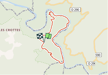

Length
7.9 km

Max alt
273 m

Uphill gradient
383 m
Km-Effort
13 km

Min alt
62 m

Downhill gradient
383 m
Boucle
Yes
Creation date :
2020-06-05 19:33:15.839
Updated on :
2020-06-08 20:37:19.63
2h39
Difficulty : Medium

FREE GPS app for hiking
 SityTrail
IGN / Geographical institutes
SityTrail Plus
The world is yours!
About
Trail Walking of 7.9 km to be discovered at Auvergne-Rhône-Alpes, Ardèche, Labastide-de-Virac. This trail is proposed by dansmabulle.
Positioning
Country:
France
Region :
Auvergne-Rhône-Alpes
Department/Province :
Ardèche
Municipality :
Labastide-de-Virac
Location:
Unknown
Start:(Dec)
Start:(UTM)
615822 ; 4911881 (31T) N.
Comments