Trail On foot Vöhrenbach - Westweg Day 3 Kalte Herberge to Titisee - Photo

Westweg Day 3 Kalte Herberge to Titisee

© OpenStreetMap contributors
Length
Length
21 km
Max alt
Max alt
1201 m
Uphill gradient
Uphill gradient
494 m
Km-Effort
Km-Effort  
28 km
Min alt
Min alt
856 m
Downhill gradient
Downhill gradient
662 m
Boucle
Boucle
No
Creation date :
2020-06-06 19:47:30.355
Updated on :
2020-06-06 20:59:23.22

(0 Reviews)

On foot
On foot
--
Difficulty : Medium

Scan this QR Code to open this trail in the SityTrail application

FREE GPS app for hiking

Logo SityTrail SityTrail

IGN / Geographical institutes

Download SityTrail from the App Store Download SityTrail from Google Play

Logo SityTrail SityTrail World

The world is yours!

Download SityTrail from the App Store Download SityTrail from Google Play Download SityTrail on Huawei AppGallery

About

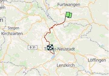
Trail On foot of 21 km to be discovered at Baden-Württemberg, Schwarzwald-Baar-Kreis, Vöhrenbach. This trail is proposed by MathieuBourgois.

Description

Doldenbühl 9.5km et 290D  Alt. 1098m
Fahrenberger Höhe 12km et 365D  Alt.1132m
Weibtannenhöhe 15km et 460D  Alt.1190m
Titisee 21km et 500D

Elevation profile

Positioning

Country:
Germany
Region :
Baden-Württemberg
Department/Province :
Schwarzwald-Baar-Kreis
Municipality :
Vöhrenbach
Location:
Unknown
Start:(UTM)
440113 ; 5316657 (32U) N.

Trails nearby

Trail On foot Vöhrenbach - DE-noch unvollständig, geht weiter - Photo
On foot
PRO

On foot

Easy
Vöhrenbach, Baden-Württemberg, Schwarzwald-Baar-Kreis, Germany
8 km | 10.1 km-effort
2h 18min
No
Trail On foot Furtwangen im Schwarzwald - Furtwangen - ? - Photo
On foot
PRO

On foot

Easy
Furtwangen im Schwarzwald, Baden-Württemberg, Schwarzwald-Baar-Kreis, Germany
3.3 km | 4.6 km-effort
1h 3min
No


Close
My subscriptions