


20200607 morancey

Jeanclaudebic
User
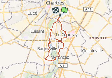

Length
12.2 km

Max alt
152 m

Uphill gradient
86 m
Km-Effort
13.3 km

Min alt
126 m

Downhill gradient
86 m
Boucle
Yes
Creation date :
2020-06-07 05:53:00.025
Updated on :
2020-06-07 08:01:00.272
2h07
Difficulty : Very easy

FREE GPS app for hiking
 SityTrail
IGN / Geographical institutes
SityTrail Plus
The world is yours!
About
Trail Walking of 12.2 km to be discovered at Centre-Loire Valley, Eure-et-Loir, Chartres. This trail is proposed by Jeanclaudebic.
Positioning
Country:
France
Region :
Centre-Loire Valley
Department/Province :
Eure-et-Loir
Municipality :
Chartres
Location:
Unknown
Start:(Dec)
Start:(UTM)
388575 ; 5365545 (31U) N.
Comments