


2020-06-07 Taverny

Bernardb44
User
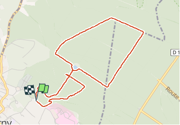

Length
5 km

Max alt
193 m

Uphill gradient
67 m
Km-Effort
5.9 km

Min alt
142 m

Downhill gradient
70 m
Boucle
Yes
Creation date :
2020-06-07 09:02:22.004
Updated on :
2020-06-07 10:01:53.503
59m
Difficulty : Very easy

FREE GPS app for hiking
 SityTrail
IGN / Geographical institutes
SityTrail Plus
The world is yours!
About
Trail Walking of 5 km to be discovered at Ile-de-France, Val-d'Oise, Taverny. This trail is proposed by Bernardb44.
Positioning
Country:
France
Region :
Ile-de-France
Department/Province :
Val-d'Oise
Municipality :
Taverny
Location:
Unknown
Start:(Dec)
Start:(UTM)
443779 ; 5430987 (31U) N.
Comments