


Tour du malmont

Sugg
User
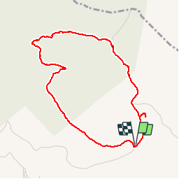

Length
4.6 km

Max alt
554 m

Uphill gradient
101 m
Km-Effort
6 km

Min alt
492 m

Downhill gradient
102 m
Boucle
Yes
Creation date :
2019-03-22 17:00:20.228
Updated on :
2019-03-22 17:00:20.313
1h20
Difficulty : Very easy

FREE GPS app for hiking
 SityTrail
IGN / Geographical institutes
SityTrail Plus
The world is yours!
About
Trail Walking of 4.6 km to be discovered at Provence-Alpes-Côte d'Azur, Var, Draguignan. This trail is proposed by Sugg.
Description
Petite balade autour du Malmont pour prendre l'air....
A voir : la table d'orientation, le sentier botanique, " l'ancien dépôt d'ordures ", le balltrap, la citerne taguée près du parking.
Photos


Positioning
Country:
France
Region :
Provence-Alpes-Côte d'Azur
Department/Province :
Var
Municipality :
Draguignan
Location:
Unknown
Start:(Dec)
Start:(UTM)
295319 ; 4825772 (32T) N.
Comments
