


Forêt Anlier

Airelle
User
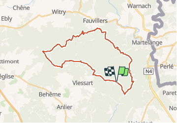

Length
31 km

Max alt
525 m

Uphill gradient
651 m
Km-Effort
40 km

Min alt
395 m

Downhill gradient
644 m
Boucle
Yes
Creation date :
2020-06-07 07:02:24.0
Updated on :
2020-06-07 14:27:59.201
7h23
Difficulty : Very difficult

FREE GPS app for hiking
 SityTrail
IGN / Geographical institutes
SityTrail Plus
The world is yours!
About
Trail Walking of 31 km to be discovered at Wallonia, Luxembourg, Martelange. This trail is proposed by Airelle.
Positioning
Country:
Belgium
Region :
Wallonia
Department/Province :
Luxembourg
Municipality :
Martelange
Location:
Martelange
Start:(Dec)
Start:(UTM)
693932 ; 5519313 (31U) N.
Comments