


roquefort-trail-28-km-804-d

HG74250
User
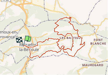

Length
28 km

Max alt
560 m

Uphill gradient
1015 m
Km-Effort
42 km

Min alt
146 m

Downhill gradient
1021 m
Boucle
Yes
Creation date :
2020-06-07 16:34:17.631
Updated on :
2020-06-07 16:38:08.304
--
Difficulty : Unknown

FREE GPS app for hiking
 SityTrail
IGN / Geographical institutes
SityTrail Plus
The world is yours!
About
Trail Trail of 28 km to be discovered at Provence-Alpes-Côte d'Azur, Bouches-du-Rhône, Roquefort-la-Bédoule. This trail is proposed by HG74250.
Positioning
Country:
France
Region :
Provence-Alpes-Côte d'Azur
Department/Province :
Bouches-du-Rhône
Municipality :
Roquefort-la-Bédoule
Location:
Unknown
Start:(Dec)
Start:(UTM)
709933 ; 4791708 (31T) N.
Comments