


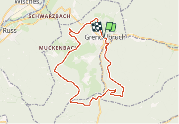
Rando autour de Grendelbruch

vaillantjm
User


5h40
Difficulty : Difficult

FREE GPS app for hiking
 SityTrail
IGN / Geographical institutes
SityTrail Plus
The world is yours!
About
Trail Walking of 16.7 km to be discovered at Grand Est, Bas-Rhin, Grendelbruch. This trail is proposed by vaillantjm.
Description
Belle variété de sentiers, principalement en forêt. Le Signal de Grendelbuch est est un vaste espace ouvert et grandiose. Quelques points de vue magnifiques. Pas de réelles difficultés sur le parcours. Merci à daft27!
Positioning
Comments