


gem-trail-2014

HG74250
User
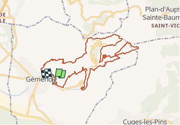

Length
26 km

Max alt
1016 m

Uphill gradient
1663 m
Km-Effort
48 km

Min alt
168 m

Downhill gradient
1663 m
Boucle
Yes
Creation date :
2020-06-07 17:08:09.739
Updated on :
2020-06-07 17:13:53.703
--
Difficulty : Difficult

FREE GPS app for hiking
 SityTrail
IGN / Geographical institutes
SityTrail Plus
The world is yours!
About
Trail Trail of 26 km to be discovered at Provence-Alpes-Côte d'Azur, Bouches-du-Rhône, Gémenos. This trail is proposed by HG74250.
Positioning
Country:
France
Region :
Provence-Alpes-Côte d'Azur
Department/Province :
Bouches-du-Rhône
Municipality :
Gémenos
Location:
Unknown
Start:(Dec)
Start:(UTM)
714045 ; 4796797 (31T) N.
Comments