


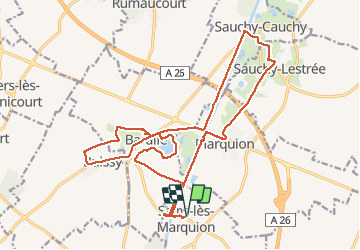
Marquion

jpblimond
User

Length
21 km

Max alt
78 m

Uphill gradient
129 m
Km-Effort
23 km

Min alt
39 m

Downhill gradient
128 m
Boucle
Yes
Creation date :
2020-06-07 11:10:25.112
Updated on :
2020-06-07 17:42:50.322
4h58
Difficulty : Medium

FREE GPS app for hiking
 SityTrail
IGN / Geographical institutes
SityTrail Plus
The world is yours!
About
Trail Walking of 21 km to be discovered at Hauts-de-France, Pas-de-Calais, Sains-lès-Marquion. This trail is proposed by jpblimond.
Positioning
Country:
France
Region :
Hauts-de-France
Department/Province :
Pas-de-Calais
Municipality :
Sains-lès-Marquion
Location:
Unknown
Start:(Dec)
Start:(UTM)
505140 ; 5560251 (31U) N.
Comments