


Haut Pinchinier

jmheydorff
User
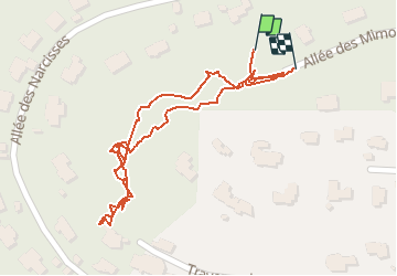

Length
691 m

Max alt
188 m

Uphill gradient
29 m
Km-Effort
1.1 km

Min alt
145 m

Downhill gradient
26 m
Boucle
Yes
Creation date :
2020-06-08 06:56:00.0
Updated on :
2020-06-08 07:21:35.09
26m
Difficulty : Very difficult

FREE GPS app for hiking
 SityTrail
IGN / Geographical institutes
SityTrail Plus
The world is yours!
About
Trail Walking of 691 m to be discovered at Provence-Alpes-Côte d'Azur, Var, Carqueiranne. This trail is proposed by jmheydorff.
Positioning
Country:
France
Region :
Provence-Alpes-Côte d'Azur
Department/Province :
Var
Municipality :
Carqueiranne
Location:
Unknown
Start:(Dec)
Start:(UTM)
264330 ; 4774898 (32T) N.
Comments