


Méréville Xeilley Thelod 2020 1

JeanPierreNancy
User
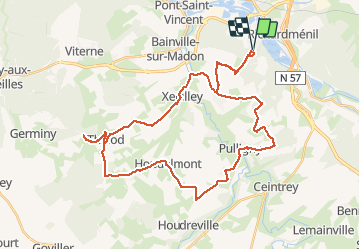

Length
42 km

Max alt
428 m

Uphill gradient
613 m
Km-Effort
50 km

Min alt
218 m

Downhill gradient
614 m
Boucle
Yes
Creation date :
2020-06-08 12:45:22.451
Updated on :
2020-06-08 15:40:35.616
2h32
Difficulty : Medium

FREE GPS app for hiking
 SityTrail
IGN / Geographical institutes
SityTrail Plus
The world is yours!
About
Trail Mountain bike of 42 km to be discovered at Grand Est, Meurthe-et-Moselle, Méréville. This trail is proposed by JeanPierreNancy.
Positioning
Country:
France
Region :
Grand Est
Department/Province :
Meurthe-et-Moselle
Municipality :
Méréville
Location:
Unknown
Start:(Dec)
Start:(UTM)
289745 ; 5385447 (32U) N.
Comments