


Esparon au bord du lac

claude nier
User
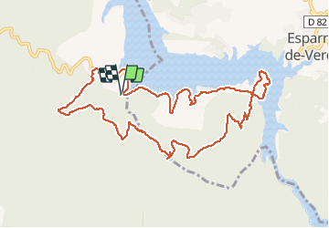

Length
12.3 km

Max alt
555 m

Uphill gradient
335 m
Km-Effort
16.8 km

Min alt
357 m

Downhill gradient
338 m
Boucle
Yes
Creation date :
2020-06-08 08:20:26.991
Updated on :
2020-06-09 06:54:36.064
3h50
Difficulty : Easy

FREE GPS app for hiking
 SityTrail
IGN / Geographical institutes
SityTrail Plus
The world is yours!
About
Trail Walking of 12.3 km to be discovered at Provence-Alpes-Côte d'Azur, Var, Saint-Julien. This trail is proposed by claude nier.
Description
petite rando sympa
Positioning
Country:
France
Region :
Provence-Alpes-Côte d'Azur
Department/Province :
Var
Municipality :
Saint-Julien
Location:
Unknown
Start:(Dec)
Start:(UTM)
736533 ; 4846344 (31T) N.
Comments