


3-60 Villeconin-Etrechy-Villeneuve sur Auvers 62 km

Lucquiaud
User
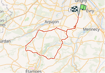

Length
62 km

Max alt
156 m

Uphill gradient
498 m
Km-Effort
69 km

Min alt
57 m

Downhill gradient
500 m
Boucle
No
Creation date :
2020-06-09 06:55:29.852
Updated on :
2021-02-22 18:31:13.731
3h04
Difficulty : Medium

FREE GPS app for hiking
 SityTrail
IGN / Geographical institutes
SityTrail Plus
The world is yours!
About
Trail Road bike of 62 km to be discovered at Ile-de-France, Essonne, Bondoufle. This trail is proposed by Lucquiaud.
Positioning
Country:
France
Region :
Ile-de-France
Department/Province :
Essonne
Municipality :
Bondoufle
Location:
Unknown
Start:(Dec)
Start:(UTM)
454093 ; 5384734 (31U) N.
Comments