


Rustrel les ocres

dan69390
User
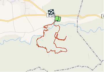

Length
5.3 km

Max alt
430 m

Uphill gradient
98 m
Km-Effort
6.6 km

Min alt
353 m

Downhill gradient
86 m
Boucle
Yes
Creation date :
2020-06-11 08:53:20.0
Updated on :
2020-06-11 11:31:03.864
1h46
Difficulty : Unknown

FREE GPS app for hiking
 SityTrail
IGN / Geographical institutes
SityTrail Plus
The world is yours!
About
Trail Walking of 5.3 km to be discovered at Provence-Alpes-Côte d'Azur, Vaucluse, Rustrel. This trail is proposed by dan69390.
Positioning
Country:
France
Region :
Provence-Alpes-Côte d'Azur
Department/Province :
Vaucluse
Municipality :
Rustrel
Location:
Unknown
Start:(Dec)
Start:(UTM)
700717 ; 4865807 (31T) N.
Comments