


La Moutière

olivieraron
User
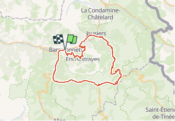

Length
72 km

Max alt
2655 m

Uphill gradient
2372 m
Km-Effort
104 km

Min alt
1123 m

Downhill gradient
2369 m
Boucle
Yes
Creation date :
2020-06-12 08:49:07.174
Updated on :
2020-06-12 08:50:47.05

FREE GPS app for hiking
 SityTrail
IGN / Geographical institutes
SityTrail Plus
The world is yours!
About
Trail of 72 km to be discovered at Provence-Alpes-Côte d'Azur, Alpes-de-Haute-Provence, Barcelonnette. This trail is proposed by olivieraron.


Positioning
Country:
France
Region :
Provence-Alpes-Côte d'Azur
Department/Province :
Alpes-de-Haute-Provence
Municipality :
Barcelonnette
Location:
Unknown
Start:(Dec)
Start:(UTM)
312634 ; 4917271 (32T) N.
Comments