


La Serre de Pan depuis Saligos en boucle

mitch1952
User
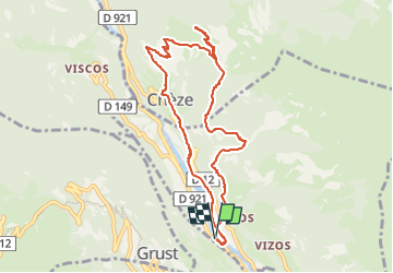

Length
9.9 km

Max alt
1328 m

Uphill gradient
752 m
Km-Effort
19.9 km

Min alt
633 m

Downhill gradient
753 m
Boucle
Yes
Creation date :
2020-06-12 15:08:33.486
Updated on :
2022-06-07 09:55:24.74
3h57
Difficulty : Difficult

FREE GPS app for hiking
 SityTrail
IGN / Geographical institutes
SityTrail Plus
The world is yours!
About
Trail Walking of 9.9 km to be discovered at Occitania, Hautespyrenees, Saligos. This trail is proposed by mitch1952.
Positioning
Country:
France
Region :
Occitania
Department/Province :
Hautespyrenees
Municipality :
Saligos
Location:
Saligos
Start:(Dec)
Start:(UTM)
743110 ; 4752993 (30T) N.
Comments