


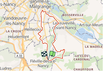
Fleville et parcs 14 kms

Marin B
User

Length
14.4 km

Max alt
257 m

Uphill gradient
149 m
Km-Effort
16.4 km

Min alt
200 m

Downhill gradient
148 m
Boucle
Yes
Creation date :
2020-06-12 12:10:30.481
Updated on :
2020-10-15 08:57:57.906
3h57
Difficulty : Medium

FREE GPS app for hiking
 SityTrail
IGN / Geographical institutes
SityTrail Plus
The world is yours!
About
Trail Walking of 14.4 km to be discovered at Grand Est, Meurthe-et-Moselle, Fléville-devant-Nancy. This trail is proposed by Marin B.
Description
Rando sans difficulté notoire. Entre nature canal et parcs.
Positioning
Country:
France
Region :
Grand Est
Department/Province :
Meurthe-et-Moselle
Municipality :
Fléville-devant-Nancy
Location:
Unknown
Start:(Dec)
Start:(UTM)
294601 ; 5389893 (32U) N.
Comments