


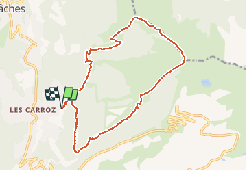
Boucle les Carroz Pointe de Cupoire

reneperrin
User


3h23
Difficulty : Easy

FREE GPS app for hiking
 SityTrail
IGN / Geographical institutes
SityTrail Plus
The world is yours!
About
Trail Walking of 9.8 km to be discovered at Auvergne-Rhône-Alpes, Upper Savoy, Arâches-la-Frasse. This trail is proposed by reneperrin.
Description
au départ du parking de la télécabine, on suit le chemin qui longe la piste. On rejoint le ruisseau de Gron qu'on traverse pour remonter vers les Tronchets, on continue jusqu'à la pointe de Cupoire. On redescend ensuite en suivant l'arrête, ne pas hésiter à prendre le chemin piéton en forêt qui longe la piste du côté gauche en descente. Enfin on traverse à droite et on redescend vers les Carroz par la forêt.
Photos


Positioning
Comments