


GR_37_DH_05_Bon-Repos-Blavet_Plouguernevel_20200613

patrickdanilo
User
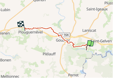

Length
16.3 km

Max alt
247 m

Uphill gradient
378 m
Km-Effort
21 km

Min alt
125 m

Downhill gradient
293 m
Boucle
No
Creation date :
2020-06-13 08:51:32.775
Updated on :
2022-02-09 13:42:11.851
4h36
Difficulty : Medium

FREE GPS app for hiking
 SityTrail
IGN / Geographical institutes
SityTrail Plus
The world is yours!
About
Trail Walking of 16.3 km to be discovered at Brittany, Côtes-d'Armor, Bon Repos sur Blavet. This trail is proposed by patrickdanilo.
Description
GR®37
Cœur de la Bretagne
Du Mont-Saint-Michel (Manche) Normandie
à Camaret-sur-Mer (Finistère) Bretagne
780km
Photos


Positioning
Country:
France
Region :
Brittany
Department/Province :
Côtes-d'Armor
Municipality :
Bon Repos sur Blavet
Location:
Laniscat
Start:(Dec)
Start:(UTM)
490383 ; 5339918 (30U) N.
Comments