


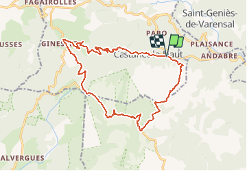
Herault - Castanet-le-Haut Chapelle de Ste-Eutrope Col de l Ourtigas 19km 832m

RandoVal
User

Length
19.1 km

Max alt
1124 m

Uphill gradient
892 m
Km-Effort
31 km

Min alt
415 m

Downhill gradient
895 m
Boucle
Yes
Creation date :
2020-06-13 20:40:58.496
Updated on :
2020-06-15 05:28:53.828
6h20
Difficulty : Very difficult

FREE GPS app for hiking
 SityTrail
IGN / Geographical institutes
SityTrail Plus
The world is yours!
About
Trail Walking of 19.1 km to be discovered at Occitania, Hérault, Castanet-le-Haut. This trail is proposed by RandoVal.
Description
Boucle dans le massif de l'Espinouse, à Castanet-le-Haut, départ et stationnement au parking de l'ancien moulin de Nougayrol, sens horaire, Bonne montée pour démarrer, retour par la vallée de la Mare
Positioning
Country:
France
Region :
Occitania
Department/Province :
Hérault
Municipality :
Castanet-le-Haut
Location:
Unknown
Start:(Dec)
Start:(UTM)
498575 ; 4834886 (31T) N.
Comments