


10697991-track-1592161215-942

Renefrt
User
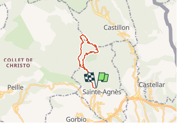

Length
11.1 km

Max alt
1229 m

Uphill gradient
688 m
Km-Effort
20 km

Min alt
585 m

Downhill gradient
688 m
Boucle
Yes
Creation date :
2020-06-14 18:59:12.0
Updated on :
2020-08-09 17:53:11.172
4h04
Difficulty : Difficult

FREE GPS app for hiking
 SityTrail
IGN / Geographical institutes
SityTrail Plus
The world is yours!
About
Trail Walking of 11.1 km to be discovered at Provence-Alpes-Côte d'Azur, Maritime Alps, Sainte-Agnès. This trail is proposed by Renefrt.
Positioning
Country:
France
Region :
Provence-Alpes-Côte d'Azur
Department/Province :
Maritime Alps
Municipality :
Sainte-Agnès
Location:
Unknown
Start:(Dec)
Start:(UTM)
375993 ; 4851082 (32T) N.
Comments