


Ste Marguerite 3

pb07
User
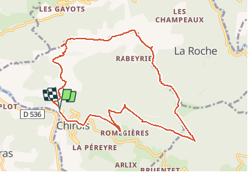

Length
10.6 km

Max alt
982 m

Uphill gradient
739 m
Km-Effort
20 km

Min alt
346 m

Downhill gradient
723 m
Boucle
Yes
Creation date :
2020-06-15 07:35:38.144
Updated on :
2020-06-15 15:27:06.161
5h22
Difficulty : Easy

FREE GPS app for hiking
 SityTrail
IGN / Geographical institutes
SityTrail Plus
The world is yours!
About
Trail Walking of 10.6 km to be discovered at Auvergne-Rhône-Alpes, Ardèche, Chirols. This trail is proposed by pb07.
Positioning
Country:
France
Region :
Auvergne-Rhône-Alpes
Department/Province :
Ardèche
Municipality :
Chirols
Location:
Unknown
Start:(Dec)
Start:(UTM)
601756 ; 4949058 (31T) N.
Comments