


Myline

AlexTremProd
User
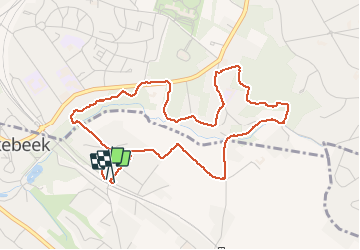

Length
4.6 km

Max alt
114 m

Uphill gradient
86 m
Km-Effort
5.8 km

Min alt
70 m

Downhill gradient
84 m
Boucle
Yes
Creation date :
2020-06-15 18:18:40.0
Updated on :
2020-06-15 19:17:05.174
58m
Difficulty : Easy

FREE GPS app for hiking
 SityTrail
IGN / Geographical institutes
SityTrail Plus
The world is yours!
About
Trail Walking of 4.6 km to be discovered at Flanders, Flemish Brabant, Linkebeek. This trail is proposed by AlexTremProd.
Positioning
Country:
Belgium
Region :
Flanders
Department/Province :
Flemish Brabant
Municipality :
Linkebeek
Location:
Linkebeek
Start:(Dec)
Start:(UTM)
594798 ; 5625253 (31U) N.
Comments