


RA 2020 Gigors

dfluzin
User
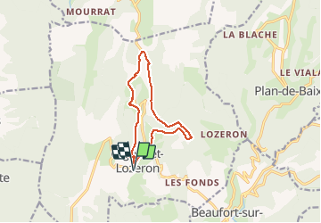

Length
11.6 km

Max alt
844 m

Uphill gradient
401 m
Km-Effort
16.9 km

Min alt
530 m

Downhill gradient
400 m
Boucle
Yes
Creation date :
2020-06-16 08:36:41.026
Updated on :
2020-06-16 13:38:08.668
4h05
Difficulty : Very easy

FREE GPS app for hiking
 SityTrail
IGN / Geographical institutes
SityTrail Plus
The world is yours!
About
Trail Walking of 11.6 km to be discovered at Auvergne-Rhône-Alpes, Drôme, Gigors-et-Lozeron. This trail is proposed by dfluzin.
Positioning
Country:
France
Region :
Auvergne-Rhône-Alpes
Department/Province :
Drôme
Municipality :
Gigors-et-Lozeron
Location:
Unknown
Start:(Dec)
Start:(UTM)
666603 ; 4961850 (31T) N.
Comments