


lance tonton

celste
User
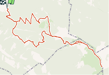

Length
17.3 km

Max alt
1327 m

Uphill gradient
934 m
Km-Effort
30 km

Min alt
445 m

Downhill gradient
934 m
Boucle
Yes
Creation date :
2020-06-17 07:34:59.925
Updated on :
2020-06-17 11:59:00.103
4h09
Difficulty : Very easy

FREE GPS app for hiking
 SityTrail
IGN / Geographical institutes
SityTrail Plus
The world is yours!
About
Trail Walking of 17.3 km to be discovered at Auvergne-Rhône-Alpes, Drôme, Roche-Saint-Secret-Béconne. This trail is proposed by celste.
Positioning
Country:
France
Region :
Auvergne-Rhône-Alpes
Department/Province :
Drôme
Municipality :
Roche-Saint-Secret-Béconne
Location:
Unknown
Start:(Dec)
Start:(UTM)
662850 ; 4927161 (31T) N.
Comments