


Trail(74): Bonneville Kartesis -1- 9 km - 178 m+

HG74250
User
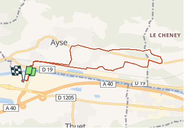

Length
9.3 km

Max alt
591 m

Uphill gradient
178 m
Km-Effort
11.7 km

Min alt
447 m

Downhill gradient
178 m
Boucle
Yes
Creation date :
2020-06-18 09:45:19.637
Updated on :
2020-06-18 19:12:10.244
1h00
Difficulty : Easy

FREE GPS app for hiking
 SityTrail
IGN / Geographical institutes
SityTrail Plus
The world is yours!
About
Trail Running of 9.3 km to be discovered at Auvergne-Rhône-Alpes, Upper Savoy, Bonneville. This trail is proposed by HG74250.
Positioning
Country:
France
Region :
Auvergne-Rhône-Alpes
Department/Province :
Upper Savoy
Municipality :
Bonneville
Location:
Unknown
Start:(Dec)
Start:(UTM)
300906 ; 5105394 (32T) N.
Comments