


tourves cabri de caramy

michelpaulin
User
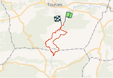

Length
12.9 km

Max alt
428 m

Uphill gradient
293 m
Km-Effort
16.8 km

Min alt
272 m

Downhill gradient
292 m
Boucle
No
Creation date :
2020-06-16 07:49:47.103
Updated on :
2020-06-19 08:24:48.807
5h55
Difficulty : Medium

FREE GPS app for hiking
 SityTrail
IGN / Geographical institutes
SityTrail Plus
The world is yours!
About
Trail Walking of 12.9 km to be discovered at Provence-Alpes-Côte d'Azur, Var, Tourves. This trail is proposed by michelpaulin.
Description
belle rando
Positioning
Country:
France
Region :
Provence-Alpes-Côte d'Azur
Department/Province :
Var
Municipality :
Tourves
Location:
Unknown
Start:(Dec)
Start:(UTM)
737715 ; 4808702 (31T) N.
Comments