


Termes ( Aude ) + les gorges de Terminet +le Nitable roc

MarieFrancoise
User


6h57
Difficulty : Medium

FREE GPS app for hiking
 SityTrail
IGN / Geographical institutes
SityTrail Plus
The world is yours!
About
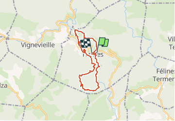
Trail Walking of 15.8 km to be discovered at Occitania, Aude, Termes. This trail is proposed by MarieFrancoise.
Description
Départ du parking à l entrée de Termes.la rando se compose de 2 parties .les gorges de Termenet et le château puis en second le Nitable roc .La 1ère partie est plus jolie et on peut se baigner dans les magnifiques gorges .si on ne souhaite pas faire la seconde partie qui compte 200 m de dénivelé et environ 7 km)on peut après le château rentrer au village qui est très typique .il y a un café .
déconseillé l 'été bien que le parcours se fasse en grande partie en forêt.
il y a dans chaque partie une descente assez raide à signaler.
Photos
 + les gorges de Terminet +le Nitable roc - Photo 1")
 + les gorges de Terminet +le Nitable roc - Photo 2")
 + les gorges de Terminet +le Nitable roc - Photo 3")
 + les gorges de Terminet +le Nitable roc - Photo 4")
 + les gorges de Terminet +le Nitable roc - Photo 5")
 + les gorges de Terminet +le Nitable roc - Photo 6")
 + les gorges de Terminet +le Nitable roc - Photo 7")
 + les gorges de Terminet +le Nitable roc - Photo 8")
 + les gorges de Terminet +le Nitable roc - Photo 9")
 + les gorges de Terminet +le Nitable roc - Photo 10")
 + les gorges de Terminet +le Nitable roc - Photo 11")
 + les gorges de Terminet +le Nitable roc - Photo 12")
 + les gorges de Terminet +le Nitable roc - Photo 13")
 + les gorges de Terminet +le Nitable roc - Photo 14")
 + les gorges de Terminet +le Nitable roc - Photo 15")
 + les gorges de Terminet +le Nitable roc - Photo 16")
 + les gorges de Terminet +le Nitable roc - Photo 17")
 + les gorges de Terminet +le Nitable roc - Photo 18")
 + les gorges de Terminet +le Nitable roc - Photo 19")
 + les gorges de Terminet +le Nitable roc - Photo 20")
 + les gorges de Terminet +le Nitable roc - Photo 21")
 + les gorges de Terminet +le Nitable roc - Photo 22")
 + les gorges de Terminet +le Nitable roc - Photo 23")
 + les gorges de Terminet +le Nitable roc - Photo 24")
 + les gorges de Terminet +le Nitable roc - Photo 25")
25 photos in total. Please click on a photo to see them all in the gallery.
Positioning
Comments