


Gorges Trévans

soca
User
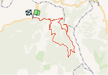

Length
11.8 km

Max alt
898 m

Uphill gradient
549 m
Km-Effort
19.1 km

Min alt
601 m

Downhill gradient
547 m
Boucle
Yes
Creation date :
2020-06-19 07:57:29.088
Updated on :
2020-06-20 05:53:42.41
4h28
Difficulty : Very easy

FREE GPS app for hiking
 SityTrail
IGN / Geographical institutes
SityTrail Plus
The world is yours!
About
Trail Walking of 11.8 km to be discovered at Provence-Alpes-Côte d'Azur, Alpes-de-Haute-Provence, Estoublon. This trail is proposed by soca.
Positioning
Country:
France
Region :
Provence-Alpes-Côte d'Azur
Department/Province :
Alpes-de-Haute-Provence
Municipality :
Estoublon
Location:
Unknown
Start:(Dec)
Start:(UTM)
277060 ; 4869797 (32T) N.
Comments