


Oberes Malcantone

bffcuc
User
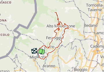

Length
18.3 km

Max alt
1042 m

Uphill gradient
856 m
Km-Effort
30 km

Min alt
585 m

Downhill gradient
854 m
Boucle
Yes
Creation date :
2014-12-11 00:00:00.0
Updated on :
2014-12-11 00:00:00.0
4h32
Difficulty : Unknown

FREE GPS app for hiking
 SityTrail
IGN / Geographical institutes
SityTrail Plus
The world is yours!
About
Trail Other activity of 18.3 km to be discovered at Ticino, Distretto di Lugano, Miglieglia. This trail is proposed by bffcuc.
Positioning
Country:
Switzerland
Region :
Ticino
Department/Province :
Distretto di Lugano
Municipality :
Miglieglia
Location:
Unknown
Start:(Dec)
Start:(UTM)
488900 ; 5096697 (32T) N.
Comments