


2020 06-20 Bénac

josy31
User
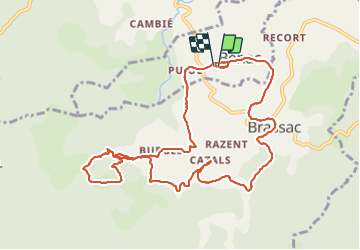

Length
12.9 km

Max alt
855 m

Uphill gradient
418 m
Km-Effort
18.4 km

Min alt
527 m

Downhill gradient
419 m
Boucle
Yes
Creation date :
2020-06-20 07:03:32.956
Updated on :
2021-08-01 17:02:43.405
3h49
Difficulty : Very easy

FREE GPS app for hiking
 SityTrail
IGN / Geographical institutes
SityTrail Plus
The world is yours!
About
Trail Walking of 12.9 km to be discovered at Occitania, Ariège, Bénac. This trail is proposed by josy31.
Positioning
Country:
France
Region :
Occitania
Department/Province :
Ariège
Municipality :
Bénac
Location:
Unknown
Start:(Dec)
Start:(UTM)
379861 ; 4756717 (31T) N.
Comments