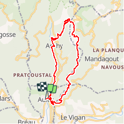
AULAS - 17.2Km - 07h00 - Dénivelé 600 m

dansmabulle
User


5h16
Difficulty : Difficult

FREE GPS app for hiking
 SityTrail
IGN / Geographical institutes
SityTrail Plus
The world is yours!
About
Trail Walking of 16.7 km to be discovered at Occitania, Gard, Aulas. This trail is proposed by dansmabulle.
Description
AULAS17.
2Km - 07:h00
Départ randonnée : Village de Aulas
( Gard 30 ) Depuis le village, vous montez en "S" vers l'Est pour atteindre la crête.Vous suivez cette crête en direction du Nord jusqu'à arriver au dessus du village Arphy.Vous descendez alors vers Arhpy que vous traversez.Le retour est sans difficulté le long du vallon jusqu'à votre point de départ.Comptez une bonne journée de marche pour cette randonnée.Bonne randonnée.
Positioning
Comments