


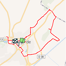
BELLEGARDE - 10.7Km 03h00 - Dénivelé 50 m

dansmabulle
User


2h40
Difficulty : Very easy

FREE GPS app for hiking
 SityTrail
IGN / Geographical institutes
SityTrail Plus
The world is yours!
About
Trail Walking of 10.7 km to be discovered at Occitania, Gard, Bellegarde. This trail is proposed by dansmabulle.
Description
BELLEGARDE
10.7Km - 03h00
Départ randonnée :Parking des arènes de Bellegrade (Gard) Ce circuit permet de découvrir les vestiges d'un aqueduc,le Musée de l'eau et une bonne partie de village de Bellegarde.Bonne randonnée.
Positioning
Comments