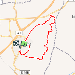
FOURNES LES FOSSES - 7.8Km - 02h00 - Dénivelé 247 m

dansmabulle
User


2h11
Difficulty : Difficult

FREE GPS app for hiking
 SityTrail
IGN / Geographical institutes
SityTrail Plus
The world is yours!
About
Trail Walking of 7.8 km to be discovered at Occitania, Gard, Fournès. This trail is proposed by dansmabulle.
Description
FOURNES LES FOSSES
7.8Km - 02:00
Départ randonnée :Parking de la mairie de Fournes-les-Fosses (Gard 30) fournes les fosses 30210 carte ign 2941ET balisage partiel jauneRando facile d'environ 2h00 sur bons sentiers et chemins à faire toute l'année. Belle vue dégagée pendant une bonne partie de la balade. Dans les fosses, paysage de terre ravinée assez singulier.Bonne balade à tous.
Positioning
Comments