


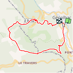
GENOLHAC - 9.2 Km - 03h30 Heures - Dénivelé 500 m

dansmabulle
User


3h12
Difficulty : Difficult

FREE GPS app for hiking
 SityTrail
IGN / Geographical institutes
SityTrail Plus
The world is yours!
About
Trail Walking of 9.3 km to be discovered at Occitania, Gard, Génolhac. This trail is proposed by dansmabulle.
Description
GENOLHAC
9.2 Km - 03h30 Heures - Dénivelé 500 mètres
Départ randonnée : Village de Génolhac (Gard 30) Randonnée de 10km à la limite des départements du Gard et de la Lozère en partant de Génolhac par l'entrée du Parc National des Cévennes côté Est du Mont-Lozère.Bonne randonnée.
Positioning
Comments
Rando sympa mais la trace n'est pas fidèle à la réalité du terrain.