


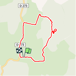
LE LUC - BALADE DU GOUFFRE - 3.8Km - 01h00 - Dénivelé 30 m

dansmabulle
User


57m
Difficulty : Medium

FREE GPS app for hiking
 SityTrail
IGN / Geographical institutes
SityTrail Plus
The world is yours!
About
Trail Walking of 3.8 km to be discovered at Occitania, Gard, Campestre-et-Luc. This trail is proposed by dansmabulle.
Description
LE LUC - BALADE DU GOUFFRE
3.8Km - 01h00
Départ randonnée : Ancienne colonie pénitentiaire de "Le Luc" Courte boucle .Au cours de la balade vu du haut du gouffre qui abritait une cave à Roquefort, puis descente "en rond" dans une doline d'où part un tunnel rejoignant le fond du gouffre.Pour le parcours du tunnel prévoir de l'éclairage.
Positioning
Comments