Trail Walking Sales - Pont Coppet - Photo
 HERRY
HERRY

User GUIDE

© OpenStreetMap contributors
Length
Length
8.6 km
Max alt
Max alt
390 m
Uphill gradient
Uphill gradient
117 m
Km-Effort
Km-Effort  
10.2 km
Min alt
Min alt
318 m
Downhill gradient
Downhill gradient
116 m
Boucle
Boucle
Yes
Creation date :
2020-06-18 12:01:04.0
Updated on :
2020-06-21 08:05:17.795

(0 Reviews)

Walking
Walking
1h53
Difficulty : Unknown

Scan this QR Code to open this trail in the SityTrail application

FREE GPS app for hiking

Logo SityTrail SityTrail

IGN / Geographical institutes

Download SityTrail from the App Store Download SityTrail from Google Play

Logo SityTrail SityTrail World

The world is yours!

Download SityTrail from the App Store Download SityTrail from Google Play Download SityTrail on Huawei AppGallery

About

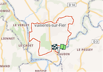
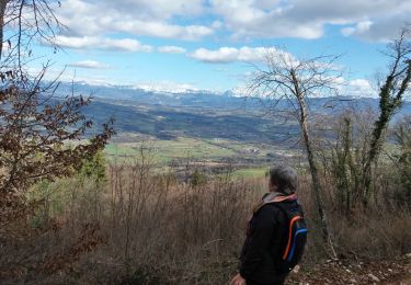
Trail Walking of 8.6 km to be discovered at Auvergne-Rhône-Alpes, Upper Savoy, Sales. This trail is proposed by HERRY.

Description

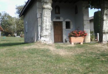
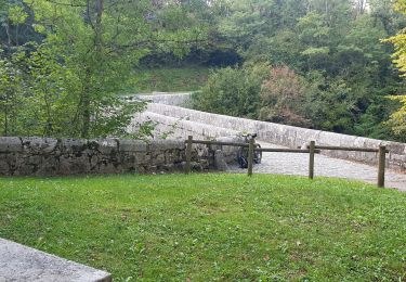
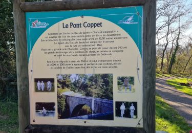
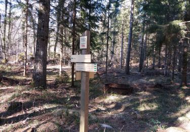
Se garer côté Sales pour apprécier la traversée du Pont Coppet et les explications sur son origine. Longer la route Rumilly-Vallières puis tourner à gauche pour longer les vergers . Suivre le sentier VTT passant au bord du Fier. Laisser le balisage VTT et se diriger vers la centrale électrique de Vallières. Remonter ensuite par la droite vers l'Eglise de Vallières. Passer par un lotissement pour monter sur les hauts de Vallières. Reprendre le balisage du sentier VTT qui ramène au Pont Coppet.

Elevation profile

Photos

Positioning

Country:
France
Region :
Auvergne-Rhône-Alpes
Department/Province :
Upper Savoy
Municipality :
Sales
Location:
Unknown
Start:(UTM)
728161 ; 5085901 (31T) N.

Trails nearby

Trail Walking Lornay - LE GROS FOUG: LORNAY - Photo
Walking
djeepee74

Walking

Medium
(1)
Lornay, Auvergne-Rhône-Alpes, Upper Savoy, France
9.1 km | 15.7 km-effort
3h 0min
Yes
Trail Mountain bike Marcellaz-Albanais - Site VTT FFC de l'Albanais - Circuit N°4 Bois aux Loups - Marcellaz-Albanais - Photo
Mountain bike
tracegps

Mountain bike

Medium
(2)
Marcellaz-Albanais, Auvergne-Rhône-Alpes, Upper Savoy, France
13.4 km | 17.6 km-effort
1h 30min
Yes
Trail Mountain bike Moye - 74- Le Gros Foug - Photo
Mountain bike
cavpsy74

Mountain bike

Difficult
(1)
Moye, Auvergne-Rhône-Alpes, Upper Savoy, France
21 km | 35 km-effort
4h 0min
Yes
Trail Walking Vaulx - VAULX - Photo
Walking
GUIDE
HERRY

Walking

Easy
Vaulx, Auvergne-Rhône-Alpes, Upper Savoy, France
8.8 km | 12.5 km-effort
2h 12min
Yes
Trail Walking Lornay - TOUR_DE_LORNAY - Photo
Walking
GUIDE
HERRY

Walking

Very easy
Lornay, Auvergne-Rhône-Alpes, Upper Savoy, France
5.5 km | 8.6 km-effort
1h 57min
Yes
Trail Mountain bike Rumilly - rando rumilly - Photo
Mountain bike
tintin73

Mountain bike

Very easy
Rumilly, Auvergne-Rhône-Alpes, Upper Savoy, France
33 km | 41 km-effort
2h 24min
Yes
Trail Walking Rumilly - Plan d'eau de Rumilly à poussette - Photo
Walking
Ladyclairdelune74

Walking

Easy
Rumilly, Auvergne-Rhône-Alpes, Upper Savoy, France
3 km | 3.4 km-effort
46min
Yes
Trail Walking Vallières-sur-Fier - VALLIERES 3 - Photo
Walking
Jean-Paulchoux

Walking

Medium
Vallières-sur-Fier, Auvergne-Rhône-Alpes, Upper Savoy, France
16 km | 19 km-effort
4h 43min
Yes
Trail Walking Moye - CLERGEON: VESTIGES CAMP 3 - MONTCLERGEON - Photo
Walking
djeepee74

Walking

Medium
Moye, Auvergne-Rhône-Alpes, Upper Savoy, France
11.4 km | 16.7 km-effort
3h 45min
Yes


Close
My subscriptions