GTJ Metabief - Pontarlier

svp59
User
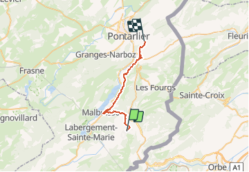

Length
25 km

Max alt
1105 m

Uphill gradient
785 m
Km-Effort
35 km

Min alt
855 m

Downhill gradient
716 m
Boucle
No
Creation date :
2014-12-10 00:00:00.0
Updated on :
2014-12-10 00:00:00.0
7h17
Difficulty : Medium

FREE GPS app for hiking
 SityTrail
IGN / Geographical institutes
SityTrail Plus
The world is yours!
About
Trail Walking of 25 km to be discovered at Bourgogne-Franche-Comté, Doubs, Métabief. This trail is proposed by svp59.
Description
GTJ etape 8
Metabief - Pontarlier
HOTEL DE FRANCE
Positioning
Country:
France
Region :
Bourgogne-Franche-Comté
Department/Province :
Doubs
Municipality :
Métabief
Location:
Unknown
Start:(Dec)
Start:(UTM)
297802 ; 5183422 (32T) N.
Comments