


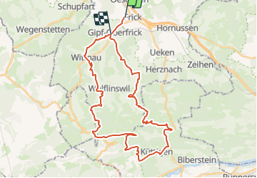
Biken Frick - Wasserfluh

Gacco
User

Length
39 km

Max alt
855 m

Uphill gradient
1433 m
Km-Effort
58 km

Min alt
353 m

Downhill gradient
1417 m
Boucle
No
Creation date :
2014-12-11 00:00:00.0
Updated on :
2014-12-11 00:00:00.0
--
Difficulty : Unknown

FREE GPS app for hiking
 SityTrail
IGN / Geographical institutes
SityTrail Plus
The world is yours!
About
Trail Winter sports of 39 km to be discovered at Aargau, Bezirk Laufenburg, Frick. This trail is proposed by Gacco.
Description
Die geplante letzte Etappe der Juratour.
Positioning
Country:
Switzerland
Region :
Aargau
Department/Province :
Bezirk Laufenburg
Municipality :
Frick
Location:
Unknown
Start:(Dec)
Start:(UTM)
425690 ; 5262033 (32T) N.
Comments