


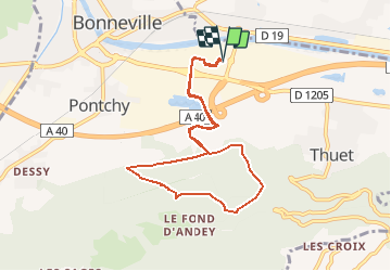
Trail(74): Bonneville Kartesis -4 Andey - 8.6 km - 861 m+

HG74250
User

Length
8.6 km

Max alt
861 m

Uphill gradient
439 m
Km-Effort
14.5 km

Min alt
446 m

Downhill gradient
439 m
Boucle
Yes
Creation date :
2020-06-22 17:13:26.045
Updated on :
2020-06-22 17:15:36.8
1h00
Difficulty : Difficult

FREE GPS app for hiking
 SityTrail
IGN / Geographical institutes
SityTrail Plus
The world is yours!
About
Trail Trail of 8.6 km to be discovered at Auvergne-Rhône-Alpes, Upper Savoy, Bonneville. This trail is proposed by HG74250.
Positioning
Country:
France
Region :
Auvergne-Rhône-Alpes
Department/Province :
Upper Savoy
Municipality :
Bonneville
Location:
Unknown
Start:(Dec)
Start:(UTM)
300906 ; 5105403 (32T) N.
Comments