


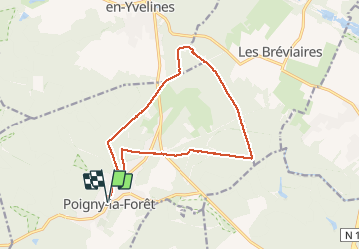
poigny la forêt 22 juin 2020

cemoi
User

Length
14.1 km

Max alt
191 m

Uphill gradient
133 m
Km-Effort
15.9 km

Min alt
144 m

Downhill gradient
132 m
Boucle
Yes
Creation date :
2020-06-22 13:44:11.533
Updated on :
2020-06-22 17:34:01.457
2h48
Difficulty : Medium

FREE GPS app for hiking
 SityTrail
IGN / Geographical institutes
SityTrail Plus
The world is yours!
About
Trail Walking of 14.1 km to be discovered at Ile-de-France, Yvelines, Poigny-la-Forêt. This trail is proposed by cemoi.
Photos


Positioning
Country:
France
Region :
Ile-de-France
Department/Province :
Yvelines
Municipality :
Poigny-la-Forêt
Location:
Unknown
Start:(Dec)
Start:(UTM)
408198 ; 5392205 (31U) N.
Comments