


25 1 14

gooogor
User
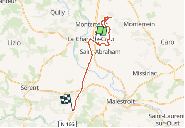

Length
21 km

Max alt
113 m

Uphill gradient
263 m
Km-Effort
24 km

Min alt
18 m

Downhill gradient
276 m
Boucle
No
Creation date :
2014-12-10 00:00:00.0
Updated on :
2014-12-10 00:00:00.0
3h08
Difficulty : Easy

FREE GPS app for hiking
 SityTrail
IGN / Geographical institutes
SityTrail Plus
The world is yours!
About
Trail Walking of 21 km to be discovered at Brittany, Morbihan, Val d'Oust. This trail is proposed by gooogor.
Positioning
Country:
France
Region :
Brittany
Department/Province :
Morbihan
Municipality :
Val d'Oust
Location:
La Chapelle-Caro
Start:(Dec)
Start:(UTM)
543564 ; 5301268 (30T) N.
Comments