


La boucle des mangues

sameja
User
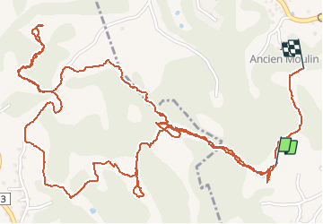

Length
6.8 km

Max alt
112 m

Uphill gradient
214 m
Km-Effort
9.6 km

Min alt
21 m

Downhill gradient
173 m
Boucle
No
Creation date :
2020-06-21 12:11:44.0
Updated on :
2020-06-24 10:41:19.78
1h48
Difficulty : Medium

FREE GPS app for hiking
 SityTrail
IGN / Geographical institutes
SityTrail Plus
The world is yours!
About
Trail Walking of 6.8 km to be discovered at Guadeloupe, Unknown, Sainte-Anne. This trail is proposed by sameja.
Description
Modette st Anne
Photos


Positioning
Country:
France
Region :
Guadeloupe
Department/Province :
Unknown
Municipality :
Sainte-Anne
Location:
Unknown
Start:(Dec)
Start:(UTM)
668768 ; 1794410 (20Q) N.
Comments