


Cenne 200625

JohnTompa
User
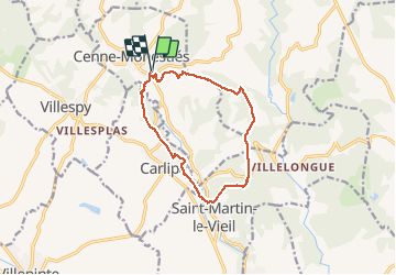

Length
12.4 km

Max alt
289 m

Uphill gradient
266 m
Km-Effort
16 km

Min alt
145 m

Downhill gradient
267 m
Boucle
Yes
Creation date :
2020-06-25 07:03:40.418
Updated on :
2020-06-25 10:59:29.522
3h55
Difficulty : Medium

FREE GPS app for hiking
 SityTrail
IGN / Geographical institutes
SityTrail Plus
The world is yours!
About
Trail Walking of 12.4 km to be discovered at Occitania, Aude, Cenne-Monestiés. This trail is proposed by JohnTompa.
Positioning
Country:
France
Region :
Occitania
Department/Province :
Aude
Municipality :
Cenne-Monestiés
Location:
Unknown
Start:(Dec)
Start:(UTM)
429018 ; 4797568 (31T) N.
Comments